
My house is in Zouk Mosbeh, but Beirut is the center between the three or four places where I spend most of my time. But then come a few times when I pass by Geitawi to see a friend, and carry on to Hamra, because that's where the life really is: from the way I see it, Hamra is Beirut as it should be, so it's the perfect region for meeting people, checking restaurants, theaters, libraries and pubs at night.
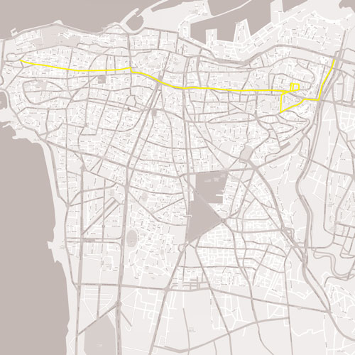
So anyway, I'll begin my journey at the western shore of the Beirut river, where I leave the Charles Helou main road (aka اوتوستراد البحر), to take the Quarantine region, at the intersection between Burj Hammoud/Mar Mikhael's Armenia street (the bridge that connects them from both shores of the river), and the recently named Corniche Pierre Gemayel. That's one of the relatively "chaotic" regions of Beirut, and I say relatively because it's more chaotic than the rest of the city: I stop at this intersection surrounded counter-clockwise, by a circus, a real-estate office tower, a gas station, a steel factory, a night-club, and a graveyard. To be more specific: the circus, Plus construction offices, Total, Nagiar, Art Lounge, and the shared grave of the Quarantine. Yet somehow, it looks quite organized, knowing that the intersection itself is well-made, with well-functioning traffic lights, and an old highway interchange.
Anyway, moving forward, we reach the puzzle bridge. After a red-light stop, I leave the Pierre Gemayel corniche to climb up to Achrafieh. Of course, there's no using that huge bridge without describing it. This is the last bit of the famous main road which connects Sin el Fil to Ashrafieh, passing over Burj Hammoud. Although I won't see it through that road, I know that many balconies have been broken down to fit that bridge, and that at some places, the bridge itself is the balcony for a couple of floors, so people can actually wake up and stop a service cab without even leaving their bedroom.
Then from a bit further, we see that the bridge has many colors: over Sin el Fil and Burj Hammoud, it's of a modern concrete bridge, with the same design and style as most of the recently constructed bridges thanks to the efforts of Lebanon's Council for Development and Reconstruction. But then, as it crosses the river, which is almost where I am right now, the bridge turns to steel blue, pretty much like Charles Helou Blvd/Emile Lahoud Blvd interchange. Anyway, now I'm climbing up a huge slope, and reaching the first traffic light, which placed in a very strange intersection. But let us ignore that for now, let's just call it the Beiruti way of building roads.
Then I'm to go left to the street just below Fassouh, a long, narrow and straight street which always looks dead and abandoned, although I'm sure it's overpopulated when I see all the cars parked on the left along the entire street. And the road leads towards The Maze. They call it Geitawi, I call it the point of no return. For months I've been going there quite frequently, and not once have I not been lost there. The buildings are old and degraded, showing a less favored part of Achrafieh's population (at least that's how it looks like, I don't mean to judge or offend anyone who lives there), yet I'm sure it's the safest place in Lebanon, because only someone living there can easily get in and out of Geitawi without being lost.
I made it in! I found Domino's pizza and the extremely narrow street which follows. It's so narrow that I have to close my car's side mirrors to go through unscratched. Picking up my friends, it's time to see the light again! Now that there are people with me who live there, it's much easier to find my way out. I wonder if I will ever memorize these streets. So buildings, buildings, narrow streets, uphill, downhill, traffic light. What? Finally, a traffic light! I know where I am! The Burj Hammoud-Tabaris main road/avenue. That road is just beautiful, and is my image of Achrafieh. In fact, it's the more modern part of town, with a well defined road, wide sidewalks, lots of well-maintained buildings, and sunlight actually shows up!
I have finally arrived to Tabaris, and the final traffic light before a pseudo-highway comes in place, also known as the Ring Road. This one is amazing! I feel that I can fly on that bridge with its hard up-slope exits (to the CBD), and its smaller exit for a U-turn under the overpass, or to access Monot and go back to Sodeco. Although I hear a lot of bad comments about Solidere's Downtown Beirut, and how they sold the city to foreigners and destroyed a heritage for the sake of artificiality and superficiality, nay building a wannabe Dubai, I am quite impressed by their work. The buildings are shiny and beautiful, and make me feel that I'm not in a third-world country for the few seconds during which I get the view over the Martyr's Square. Then, the tunnel! Nothing so special about it, except that it feels like a rollercoaster, and it takes me straight to Hamra St. I wonder why they put those 50 km/h speed limit signs, when an 80 or 100 would be acceptable. But then I realize that the sign was right. Traffic begins after the last turn in the tunnel when I go right (left is towards Ain Mreisseh). And that's the heavy traffic accessing Hamra's main street, which is where I park, facing Fransabank and start walking with the people I had just picked up.
Hamra is quite another world, as I have mentioned before, Beirut as it should be. And it's one of the rare places suitable for cars and pedestrians alike to flow comfortably. The sidewalk is wide, the car's part of the street is paved a-la-Roma, and there are parking spaces everywhere, and there is everything one needs for a basic social life: theaters, concert venues, bars, night clubs, libraries, discotheques, restaurants, residences, electronics stores, and two blocks away, is Bliss st., with the glorious AUB and IC. But for now, we're just walking straight, going first past Costa (the beginning) and ending up after Roadster, to our destination near Hotel Versailles.
That's all there is to say about this route, but I should conclude that Beirut is a huge puzzle, and the pieces are extremely different where I go by: the industrial river shores, the great bridge to the suburb-ish part of the city, the endless maze, the well-made road, the mini-highway across an artificially glorious CBD, the roller-coaster leading to an actual city street which is a world of its own. And that's the 30-minute adventure of a few times a week (10 minutes if there's no traffic jam, one or two hours if there's heavy traffic).
 DOWNLOAD & RETRACE